Mountains-To-Sea-Trail at Craven Gap
By Joanne O'Sullivan
Craven Gap Trail Details
Difficulty: Moderate
Length: 4.8 miles round trip
Region: Blue Ridge Parkway
Duration of hike: 2 hours
Elevation gain: 250 feet
Type: Out & Back
Blazes: White
Facilities & Parking: Parking lot off Blue Ridge Parkway; additional pull-off parking; no facilities
Features: Pet Friendly, Views
Directions to Trail Head | Open in Google maps
A perfect point of departure from the Parkway
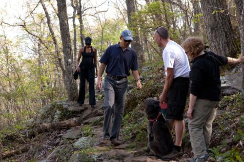
With thousands of acres of wilderness close to Asheville, where do you start to explore? For an introduction to the splendor of mountain scenery, try Craven Gap off the Blue Ridge Parkway, just 15 minutes from downtown. It’s a hike that families can enjoy. It's also the only place a president has set foot on the Parkway: President and Mrs. Obama hiked here in 2010.

LEAVE NO TRACE TIP
You will often see bears and other wildlife on this stretch of the Mountains-to-Sea Trail. Do not approach the bears or try to feed them. Observe them from a distance. Remember, this is their home!
What To Expect
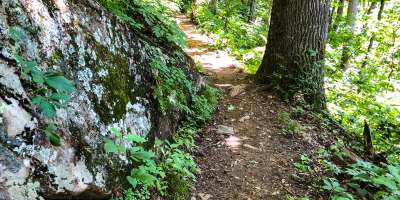
 This is a stretch of the Mountains-to-Sea Trail (MST), a trail that runs across the state of North Carolina. Most of this stretch of the MST parallels the Blue Ridge Parkway, meaning you will see the Parkway through the trees below and often hear vehicles traveling on the Parkway. There are no views along the way but given how close the trail is to town it does provide a great taste of the forest. While this stretch of the MST is one of the flattest in the mountains, there are still a mixture of small climbs and short downhill portions.
You will likely notice this trail is by many locals (there are residential areas nearby) who often run or walk from Craven Gap for exercise. In the spring it's a fun wildflower hike and in the fall leaf peepers come to see the autumn colors. There are a few "creek crossings" along the way. But these crossings are nothing more than a trickle unless after a heavy rain.
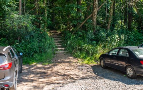 Please note there is no signage at the beginning of the trail indicate the name of the trail. The hike begins with a set of stairs from the large parking area (pictured right). Along the trail, you will notice a white "blaze" on the trees. A blaze is a symbol, in this case a small painted white circle, designed to help hikers know they are on the correct trail.
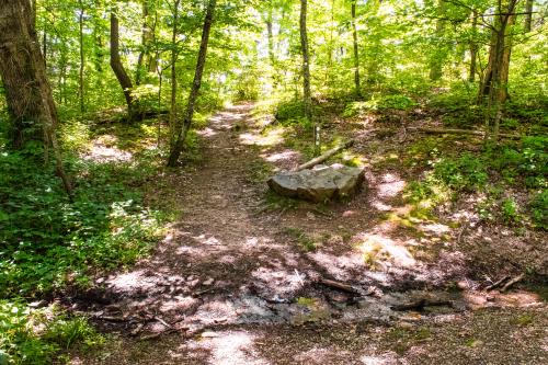
There are few landmarks along the trail save for a small footbridge about 25-30 minutes into your hike.
 When you reach the 2-mile point of the trail, you’ll be at Ox Creek Road (located at Bull Gap). This location is pictured right. From here you can turn around and go back, or add on the hike by crossing the road and following the Mountains-to-Sea Trail to Rattlesnake Lodge. This loop adds about 1.2 miles to the trail, but includes the ruins of an old family lodge.
An alternative from Craven Gap is to hike south toward the Folk Art Center. This is a 10.8-mile round-trip hike, but is not strenuous. The scenery along this stretch overlooks Haw Creek Valley, a residential section of Asheville. There is an overlook at Lunch Rocks, which is, as the name implies, a good place for a picnic. The trail to Lunch Rocks can be more easily accessed from the Folk Art Center. The trip to Lunch Rocks Overlook is 4.9 miles round trip.
The section of the Blue Ridge Parkway close to Craven Gap may be closed due to weather in the winter. The trail can still be accessed, however, by driving to the end of Webb Cove Road off of Beaverdam Road in North Asheville (please note the final two miles before the Parkway are not paved) or by Ox Creek Road in Weaverville (if this road is accessible).
Directions
From downtown Asheville, take College Street east to Town Mountain Road. Turn left onto Town Mountain Road before College Street enters the tunnel. Take Town Mountain Road to its intersection with the Blue Ridge Parkway. Turn left onto the parkway. The parking lot is just ahead at Milepost 377.4.
GPS Coordinates
N35.6479, W82.4910
We all love the Blue Ridge Mountains! By working together, we can keep these incredible outdoor spaces beautiful and pristine for years to come. Make it your nature to Leave No Trace: Leave what you find, pack out what you pack in, stay on designated trails and plan ahead. To learn more about the 7 Principles of Leave No Trace, CLICK HERE >>.