Deep Gap Trail at Mount Mitchell State Park
By Jason Tarr

A walk in the clouds in the Black Mountains
Hike from the highest peak east of the Mississippi River (Mount Mitchell, 6684 feet) to the second highest one (Mount Craig, 6647 feet). On the ridge line of these giants of the Black Mountains, you might find yourself above the clouds.
You'll begin the hike in Mount Mitchell State Park, one of the first state parks in the U.S. (established in 1915).

LEAVE NO TRACE TIP
Featuring two of the highest peaks in the East, the Deep Gap Trail has a climate that can be chilly even in the summer. Make sure to dress in layers so you can be ready for the conditions.
What to Expect
 Also called the Black Mountain Crest Trail, the Deep Gap Trail starts from the far end of the parking lot at Mount Mitchell summit (at the start of the picnic area). You’ll be able to see Mount Craig, your destination (about a 2-mile roundtrip hike), clearly from here. The trail goes through the picnic area, which is in itself very scenic, featuring an abandoned log cabin that’s been refurbished.
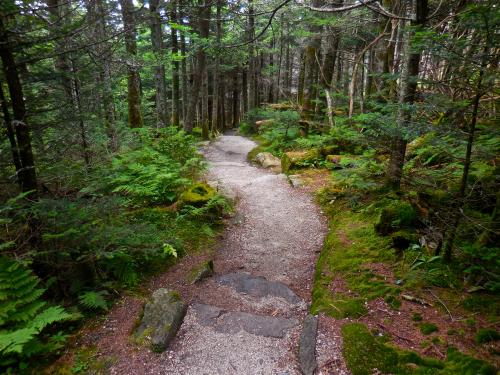
As the trail leaves the summit of Mount Mitchell, it descends into an area of alpine forest. Along the way, you’ll encounter stone steps and sometimes pass over exposed rock (which requires some scrambling). The path will be flat in places. Views are visible through gaps in the trees, but this is a wooded trail.
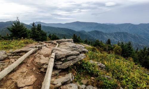 The trail begins to ascend Mount Craig at just under a half a mile. At the top, there’s a plaque marking the peak’s altitude (just 37 feet shorter than Mount Mitchell). From here, you have the option to continue on to Big Tom and the Deep Gap campground (3.5 miles further) or turn around.
Before starting out on your hike, know that the temperature here is often at least 10 (sometimes 20) degrees cooler than in Asheville. Weather conditions can change quickly. In winter, Mount Mitchell State Park may be limited.
The portion of the trail from Mount Mitchell to Mount Craig is more heavily trafficked than the additional sections.
Hike Details
|
Difficulty: Moderate to Strenuous |
Distance from Asheville: 33 miles, 1 hour 5 minutes |
Length: 2.1 miles round trip (to Mt. Craig) |
||
|
Region: Mount Mitchell State Park |
Duration of Hike: 1-1.5 hours |
Elevation Gain: 300 feet |
||
|
Pet-Friendly? Yes; leashed dogs |
Multiple Use? No |
Blazes? Orange |
Facilities & Parking: Bathroom, picnic area, water fountain, concessions and gift shop (summer and early fall), museum |
|
|
Natural Features: Alpine forest, tall peaks, rock outcroppings, rare plants |
||||
GPS Coordinates
35°46'02.5"N 82°15'52.3"W
We all love the Blue Ridge Mountains! By working together, we can keep these incredible outdoor spaces beautiful and pristine for years to come. Make it your nature to Leave No Trace: Leave what you find, pack out what you pack in, stay on designated trails and plan ahead. To learn more about the 7 Principles of Leave No Trace, CLICK HERE >>.
Photos by Jason Tarr of ExploreAsheville.com.